Here’s Why Atlantic Hurricanes Are Rapidly Developing in 2024
Hurricane Helene joins Hurricane Debby, Hurricane Francine, and Potential Tropical Cyclone Eight in an unusual string of four in a row.

Rapidly intensifying tropical storms and hurricanes give us less time to prepare and often catch people off guard. Predicting a storm’s peak intensity and its intensity at landfall is one of the most challenging aspects of weather forecasting. A significant number of storms in 2024 have undergone rapid intensification and the Atlantic hurricane season is only half over. Why are Atlantic hurricanes developing so fast, and what can we expect?
Rapid Intensification
Rapid intensification is a term that defines how quickly tropical storms and hurricanes gain strength. The threshold is at least 35 mph in 24 hours or less.
What Conditions Create Rapid Intensification?
Warm water, low wind shear, and abundant moisture are the primary factors that create rapid intensification. Not every tropical storm or hurricane will undergo rapid intensification.
The minimum temperature threshold for tropical storm development is about 80 degrees Fahrenheit.
The chances are much higher when warm water, low wind shear, and abundant moisture are combined. The depth of the warm water is most important.
Inside the Numbers
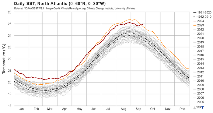
The Atlantic hurricane season started with sea surface temperatures 2.5 to 4 degrees Fahrenheit above historical averages, which were also slightly above the 2023 sea surface temperature.
However, over the past month, sea surface temperatures and ocean heat content have been below the 2023 levels.


Goldenberg and Shapiro (1996) define the Atlantic Main Development Region (MDR) as the area “from ~10° to 20°N between the west coast of Africa and Central America.” Most major hurricanes (Category 3+) form in this narrow band.

Stay Vigilant Until Early November
Sea surface temperatures are now cooling and that’s a good thing for October. But remember, it’s the depth of the warm water that matters most. Most of the time, mixing of the colder deep water cooling the surface water causes the intensity of a slow-moving hurricane to level off or weaken. With that said, named storms and hurricanes are not uncommon in late October and early November. Stay vigilant — it’s already been an unusual season for rapidly developing storms.
https://youtube.com/shorts/_FzNBgfTPjg?si=t2owztYvMaBDbBRW
References
“2024 Atlantic hurricane season is primed for storms with ‘rapid intensification’” by Alex Sosnowski, AccuWeather senior meteorologist, updated Aug 5, 2024
University of Maine
University of Miami
JD Solomon resides in the Carolinas, where he fishes, sails, and coaches baseball. Professionally, JD Solomon is the founder of JD Solomon, Inc., the creator of the FINESSE fishbone diagram®, and the co-creator of the SOAP criticality method©. JD has weathered many storms, both on land and at sea.
